A vast, low‑density zone has appeared in deep-earth scans under the Himalayas, hinting that ancient tectonic layers may be peeling away or collapsing—reshaping the way this mountain chain breathes, shifts, and stores stress.
The map pulsed with color: reds and blues, veins and shadows, like an MRI of the planet’s ribcage. On the screen, the Himalayas had a heartbeat. Somewhere beneath the ridgelines where prayer flags snap and yaks shoulder the wind, a strange dim patch bloomed—an absence where solid should be. She sipped, winced at the heat, and tapped the shape with her index finger, as if to wake it up. Something is missing.
What lies beneath the roof of the world?
The “void” isn’t empty in the sci‑fi sense. It looks more like a zone where rock has lost density and stiffness, laced with fluids and tiny melt pockets. Instruments scattered across India, Nepal, and the Tibetan Plateau picked up slow seismic speeds and odd electrical behavior there, the sort that says the basement has softened.
Early models place this anomaly tens of kilometers below the summits, stretching along parts of the central and western Himalayas. Seismic waves that should arrive on the dot show up late by a noticeable margin, and gravity readings sag a little where they’d be expected to bump. It’s the kind of pattern you get when a once‑thick layer is thinning, sagging, or sliding away out of sight. **This isn’t a cave; it’s a zone of weakened rock and fluids.**
One leading idea is delamination—the old, dense underbelly of the Indian plate detaching like a heavy carpet and sinking into deeper mantle. When that slab peels away, hot, lighter material wells upward to fill the gap, leaving a “void” in terms of rigidity. Another twist is crustal channel flow, a warm mid‑crust layer that can ooze sideways over geologic time. Put together, it’s a quiet kind of collapse down below, the slow rewiring of stress that can change how and where big quakes load.
How scientists read a void without seeing it
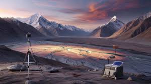
Earthquakes are the flashbulbs. Arrays of seismometers listen for how their waves bend, speed up, or lag as they cross hidden layers, like a doctor thumping a chest to hear the hollows. Magnetotellurics adds a different sense: reading Earth’s electric whispers to find wet, hot, or altered rocks, which conduct current far better than dry, cold crust.
Stack those with gravity and GPS, and you get a multi‑angle portrait. Each method has blind spots, so researchers cross‑check where their signals overlap and where they argue. Fits and misfits both matter. Let’s be honest: nobody does that every day. Yet those long, patient campaigns in valleys and yak meadows draw the outline of what we can’t dig.
“Void is a loaded word,” a field lead told me. “Think of it as a bruise in the lithosphere—less strong, more alive.”
- What it likely is: fractured rock shot through with fluids and warmth.
- Where it sits: mid to lower crust, dipping toward the mantle.
- What it does: stores and redirects stress, guides heat and water.
- What it’s not: a cavern you could fall into.
_______________________________________________________________________
Read Also : Europe is world’s fastest-warming continent, report says
________________________________________________________________________
Why this matters for quakes, rivers, and time
A softened basement changes how the Himalayas breathe. If ancient layers are peeling away, stresses can migrate, locking one segment as another loosens, shifting the timing of future ruptures. **No one is pulling a panic alarm.** It’s more like learning the mountain chain has a second set of lungs. Water listens too. Fluid‑rich zones can ferry deep brines upward, alter minerals, and tweak the roots of springs that feed great rivers born in these heights. We’ve all had that moment when a map unsettles us—a new color in a familiar place—because it hints that the ground beneath our stories is moving. Maps can scare us, but they’re just measurements. The questions they raise are invitations, not verdicts.


