We’re witnessing a massive shift in what many experts consider the single biggest determiner of natural worldwide climate: the El Niño-Southern Oscillation, or ENSO, as scientists like to call it. Much like yin and yang, this monumental weather event comprises the rival El Niño and La Niña phases that alternatively warm and cool massive areas of the tropical Pacific Ocean every 3-7 years.
This butterflies into colossal consequences for climate worldwide, disrupting atmospheric circulation patterns and jet streams, affecting temperature and precipitation in significant parts of the planet — including India.
Amid a changing planet, the La Niña conditions that prevailed until recently somewhat helped restrain global temperatures to the manageable conditions we observe right now. The cooling phenomenon managed to protect its throne for over a year and a half, and was only declared fallen early March of this year.
Since then, wasting absolutely no time, a usurping El Niño has been brewing in the books for a while, and scientists have confirmed that the proverbial pin of the grenade has been pulled all but completely.
Till last month, scientists had forecasted a 70-80% chance of El Niño formation by mid-2023. This stat has been upped to a 90% likelihood that ‘the boy’ will reclaim its throne during the May-June season, a bulletin by the Climate Prediction Center, National Center for Environmental Protection and National Weather Service advises.
________________________________________________________________________
Read Also : Home Advice Vegetables to plant in August: top 10 crops to sow and grow…
________________________________________________________________________
When is El Niño declared?
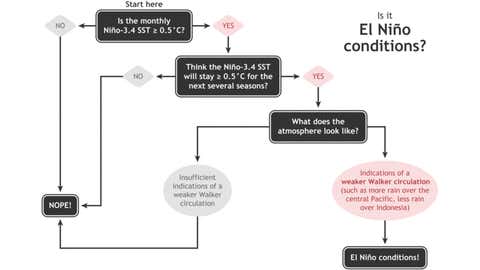
These predictions are certainly not issued all willy-nilly! A bunch of conditions must be strictly met to declare El Niño. For most models, this starts with observing whether the waters of a particular strip of water in the Pacific Ocean have warmed sufficiently (above 0.5°C) and persisted for three months.
Then, scientists look into tropical weather pattern changes, such as whether specific regions have begun receiving more and less rainfall.

(NOAA/Glen Becker/Fiona Martin)
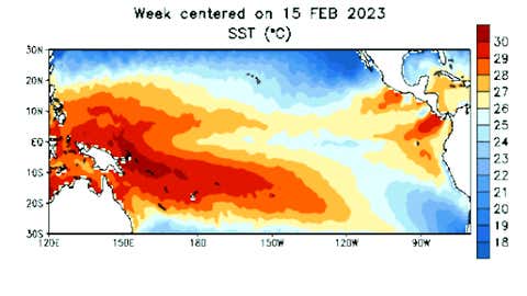
Forecasters have already begun observing rapidly heating Pacific Ocean conditions, and computer models seem to strongly agree with the ENSO shift. Datasets have shown that the average sea surface temperatures have hung around 0.1°C above the long-term average, up 0.2°C since March. However, a closer weekly look shows that we are actually straddling 0.4°C above normal — a mere 0.1°C away from the 0.5°C threshold required to satisfy one of the El Niño conditions!
________________________________________________________________________
Read Also: What is Water Footprint Assessment?
________________________________________________________________________

(NOAA)
What does this mean for global climate and people?
Not a lot of great things, experts reckon.
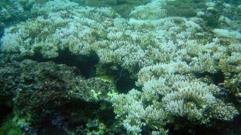
In addition to catapulting global land temperatures, an ENSO transition could further sizzle our uncharacteristically warming oceans through the roof. This could have disastrous ecological consequences for marine life, including fish and corals.
During the El Niño phases in 2015-2016, 75-99% coral losses were observed worldwide. A few fish species have been considered extinct during another catastrophic cycle.

(NOAA/David Burdick)
El Niño can also trigger droughts, affecting seedling and plant growth, and severely exacerbate wildfire occurrences.
________________________________________________________________________
Read Also: What is Water Footprint Assessment?
________________________________________________________________________
How will it impact India?
A shift to El Niño could aggravate monsoon rain deficits in the country, many experts reckon. In fact, long-range forecasts by both IMD and TWC have already predicted a below-average monsoon rainfall performance this year.
But fortunately, a neutral Indian Ocean Dipole could serve as a hero to compensate for the drying effect of El Niño. Affectionately termed the “Indian Niño”, the IOD is a climate phenomenon that affects sea surface temperature over the Indian Ocean. While a positive cycle is associated with higher-than-normal rainfall over the Indian subcontinent, even neutral conditions could result in a more stable atmosphere over the Indian Ocean, creating helpful conditions for monsoon winds to develop and strengthen over India.
Additionally, a rise in diseases has also become known to accompany El Niño cycles. India, in particular, has had to endure devastating malaria outbreaks in the past as a result.


