
The first hint that something was off came as a feeling, not a chart.
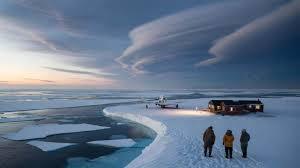
In early January, Arctic researchers stepping off a small plane in Longyearbyen, Svalbard, felt slushy snow under their boots instead of the usual knife‑sharp crunch. The air was strangely mild, soft on the skin, as if the calendar had silently skipped a month. One scientist pulled out his phone, tapped the thermometer app, then looked up at the low, hazy clouds with a quiet frown.
Up in the sky, thousands of meters above them, the polar vortex was wobbling like a spinning top losing balance.
Meteorologists are now saying that early February could be the moment that wobble turns into something deeper.
A turning point we’ll feel far from the Arctic Circle.
What’s happening above the Arctic ths\at we can’t see from our windows
On satellite maps, the Arctic in late January looks calm.
A clean white cap, ringed by swirls of cloud, like a postcard from a place that barely moves. The atmosphere above, though, is anything but calm. High in the stratosphere, winds that usually whirl in a neat, tight ring around the North Pole are fraying at the edges.
Meteorologists describe it as a “stressed” polar vortex.
Not broken. Not fine. Just… on the edge.
One example keeps popping up in research briefings.
In late December and early January, temperatures over parts of the central Arctic rose to levels normally seen in April. Some weather balloons registered air around 30°C warmer than the seasonal average at certain heights. That’s not a gentle deviation; that’s a spike.
________________________________________________________________________
At the same time, computer models began flagging early February as a window where the vortex could dramatically weaken or even split. For forecasters, those colored lines on the model charts are a warning light.
They’ve seen this pattern before — in the run‑up to some of the wildest winter anomalies of the last fifteen years.
Here’s the basic logic.
The polar vortex is like the lid on a freezer, trapping cold air over the Arctic. When that lid is firm and centered, the atmosphere is “stable”: cold stays north, milder air stays south, jet streams stay fairly straight. When the lid loosens or tilts, cold air leaks outward in lurches, and warm air punches into the Arctic from below.
Early February is shaping up as one of those moments when the lid could tilt badly.
If that happens, Arctic stability doesn’t just shift in theory — it reshuffles real weather on real streets, from Chicago to Berlin to Beijing.
How an invisible wobble over the pole can rewrite your local forecast
The practical question isn’t “Is the Arctic stressed?”
It’s: what does that mean for the week when you’re supposed to commute, take kids to school, or keep your heating bill under control? Meteorologists tracking this early‑February window are watching how the polar vortex couples with the jet stream below. The method is fairly simple to describe, even if the math behind it isn’t.
They look for three key tells: a slowing of stratospheric winds, bulging high‑pressure domes over the Arctic, and sudden kinks in the jet stream. When those line up, local forecasts can flip fast.
We’ve all been there, that moment when the forecast said “typical winter” and then, five days later, you’re staring at headlines about a historic cold snap or an eerily warm spell.
Think of February 2021 in Texas, when Arctic air was shoved deep into the southern United States, crushing energy grids and freezing pipes in homes never designed for that kind of cold. Or the strange winter of 2019 in Europe, with winter daisies blooming in some parks while snowstorms hammered the Balkans.
Those weren’t random roll‑of‑the‑dice events.
Each was tied to a disrupted polar vortex and a wobbling jet stream — the exact pattern models are flirting with again now.
The emotional whiplash comes from how lopsided the effects can be.
While one region shivers through record lows, another, just a couple of thousand kilometers away, basks in record warmth that feels almost indecent for the time of year. This see‑saw is a classic sign of lost Arctic stability: the cold hasn’t vanished, it’s just been flung around like a loose bead on a string.
Scientists are increasingly blunt about the backdrop: a warming planet thins sea ice, exposes darker ocean, and pumps extra heat into the Arctic atmosphere. That heat pushes up, jabbing at the vortex above like fingers on a drum. *You can’t disturb the top of the world this much and expect the rest of the atmosphere to behave as before.*
Reading the signs, lowering the risk, and staying sane when winter goes weird
On a practical level, there’s a small ritual meteorologists wish more people would adopt.
When the talk turns to polar vortex disruption and Arctic instability, they’d love us to glance not just at the daily forecast, but at the 6–10 day outlook map from a trusted national or regional weather service. That’s where the emerging pattern shows up first: sprawling domes of blue for below‑normal temperatures, rusty orange blobs for unseasonable warmth.
If early February brings a sharp weakening of the vortex, those maps could change quickly over a couple of days. That shift is your early nudge to prep: adjust travel if possible, insulate that drafty window, refill the pantry a little, or plan how to stay cool in case the “weird” comes in the warm direction.
There’s also the human side: the fatigue of yet another “once‑in‑a‑decade” headline.
People get tired of alert mode. When meteorologists warn that Arctic atmospheric stability might be hitting a turning point, it can sound abstract compared to rent, groceries, or getting the car started on a dark morning. Let’s be honest: nobody really pores over ensemble forecast spaghetti plots after dinner.
What helps more is simple, grounded advice.
Dress for two scenarios. Charge devices before big swings. Keep one eye on warnings from local services instead of viral screenshots. Small, boring habits that soften the edge when the atmosphere throws a curveball.
Early February is also a moment of reckoning for the experts themselves.
Behind the scenes, forecast centers quietly compare how their models are handling the vortex changes. They know that if this is a real turning point in Arctic stability, the old assumptions about winter patterns will slip further out of date.
“We’re watching the Arctic the way a doctor watches a patient’s vital signs,” one senior climatologist told me. “The numbers might look calm, then one reading jumps and suddenly you realize the baseline has changed.”
- Watch the mid‑range outlook — It’s where emerging cold blasts or warm spells show before they hit headlines.
- Follow one trusted source — National weather services, not random screenshots, for serious decisions.
- Prep lightly, not obsessively — A bit of food, warmth, backup power, or shade can go a long way.
- Use weird weather as a teaching moment — With kids, neighbors, even colleagues, to connect daily life to Arctic shifts.
- Pay attention to patterns, not single days — The trend tells you more than that one freak Tuesday.
________________________________________________________________________
What this potential turning point says about the winters we’re walking into
If early February does mark a genuine shift in Arctic atmospheric stability, it won’t arrive with a dramatic soundtrack.
No sirens, no red line drawn in the sky. It will show up as a patchwork of lived moments: a frozen bus stop in one city, puddles in a ski resort in another, rain falling on what used to be ironclad sea ice. People will text friends, post photos, shrug, complain, adapt. Then, quietly, the climate record will log another odd winter that doesn’t quite fit the old mold.
The deeper question is how many of these “odd” winters it takes before we stop calling them anomalies. If the Arctic continues warming four times faster than the global average, its atmosphere will keep losing the rigid stability that shaped much of 20th‑century weather. That doesn’t mean every winter will be extreme, only that the dice are loaded differently now.
Some readers will respond by double‑checking insulation or planning future moves away from flood‑prone or grid‑fragile regions. Others will simply start paying closer attention when scientists mention the polar vortex, instead of rolling their eyes at yet another buzzword. Both reactions are reasonable.
What’s certain is that the view from the Arctic research stations — the slushy snow, the soft air, the models lighting up around early February — will increasingly echo in how our own seasons feel at home.
How we choose to read those signs, and what we do with that knowledge, is the part of the forecast no model can write for us.
| Key point | Detail | Value for the reader |
|---|---|---|
| Arctic “lid” is loosening | Polar vortex likely to weaken or wobble in early February | Helps anticipate higher odds of unusual cold or warmth |
| Local weather can flip fast | Jet stream kinks can send Arctic air south and warm air north | Encourages flexible planning for travel, work, and home comfort |
| Patterns matter more than single days | Mid‑range outlooks and repeated “weird” winters show a trend | Supports long‑term thinking about housing, energy, and safety |
NOTE – This article was originally published in Direct Pathway and can be viewed here


