
A striking satellite image has revealed a dramatic Y-shaped landform hidden deep inside China’s Taklamakan Desert. The unusual formation appears where a rocky ridge meets a winding river that carries valuable gemstones. The remote site also contains the remains of an eighth-century military fort connected to the ancient Silk Road trade.
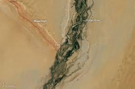
Formation in the center of the Taklamakan Desert
The formation lies in the center of the Taklamakan Desert, one of the largest sand deserts on Earth. The desert covers about 130,000 square miles (337,000 square kilometers) in the Tarim Basin of China’s Xinjiang region. For decades, scientists described the area as a “biological void” because extreme heat and dry conditions allowed very little life to survive.
However, the landscape has begun to change in recent decades. Since 1974, China has planted more than 66 billion trees along the desert’s northern edge as part of a massive ecological engineering project known as the Great Green Wall.
Researchers say the expanding forest belt now acts as a carbon sink, absorbing large amounts of carbon dioxide while helping slow desert expansion.
River of jade crosses the desert
The Y-shaped formation visible from space is created by two major natural features. One branch follows the Hotan River, which stretches about 180 miles (290 kilometers) across the desert from south to north. The river begins in the glaciers of the Kunlun Mountains, where melting ice feeds its flow across the dry basin.
From satellite images, the river often appears green. Vegetation grows between its braided streams, creating narrow strips of plant life across the desert floor. The river is also famous for its gemstone deposits.
Its waters carry white and green nephrite, prized types of jade that have been valued in Chinese culture for thousands of years. Traders and travelers historically searched the riverbed for these stones, which were used in jewelry, ritual objects, and decorative art.
Rocky ridge shapes desert winds
The second arm of the formation follows the Marzatagh ridge, a long rocky structure that rises about 600 feet (180 meters) above the surrounding sands. The ridge extends nearly 90 miles (145 kilometers) toward the northwest.
Layers of reddish iron-rich rock and lighter sandstone give the ridge a distinctive appearance. Because of these colors, the formation is locally known as Hongbaishan, meaning “red-white mountain” in Chinese.
The ridge also acts as a natural barrier to desert winds. Sand blowing across the basin collects against the rocky wall, creating fields of crescent-shaped dunes known as barchan dunes along its northern edge.
The ancient Silk Road fort still stands
Where the river and ridge meet lies the crumbling remains of an ancient fortress known as Mazar Tagh. Historical records show that the Tibetan Empire built the fort between A.D. 618 and 842, when it controlled large parts of Central Asia.
The stronghold stood on a hill overlooking the desert crossroads. Soldiers stationed there monitored movement across the Tarim Basin and protected caravans traveling along Silk Road routes that linked China with Central Asia and the Middle East.

Archaeologists first excavated the site in 1907. Hungarian-British explorer Aurel Stein uncovered more than 1,500 document fragments written on wood and paper. According to the International Dunhuang Programme, the texts appear in several languages, including Khotanese, Uyghur, and Sogdian, and describe the experiences of soldiers stationed at the remote outpost.
Excavations also revealed arrows, shoes, dice, a comb, and a pen, many of which are now preserved at the British Museum. One of the most notable discoveries was a painted portrait of a “begging monk” on a wooden board, likely created by a soldier.
Historians believe the monk may have been traveling to a Buddhist shrine that once stood on the hill. Today, the site is home to an Islamic shrine, reflecting the many cultural and religious changes that have shaped the region over centuries.
NOTE – This article was originally published in Greek Reporter and can be viewed here


