
The Indian Ocean is a climate change hot spot, and warmer sea temperatures are causing cyclones like Nivar and Amphan to intensify rapidly

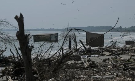
On the night of 25 November, at 11.30pm, cyclone Nivar began its landfall at Puducherry on the Tamil Nadu coast. A severe cyclonic storm (SCS) with wind speeds of 120-30 kmph, according the India Meteorological Department (IMD), Nivar finished making landfall at 2.30am on 26 November. It subsequently weakened into a cyclonic storm (CS), but not before dumping vast amounts of rainfall in the coastal areas around Chennai and Puducherry. By then, Puducherry had recorded 237mm of rainfall in 18 hours. In that same time, Cuddalore had recorded 246mm and Chennai, 83mm.
The good news is that the IMD had pinpointed the track of the cyclone as early as 23 November, and this helped with adequate warnings and evacuation from the coast. According to reports, through the 25th, thousands of families were evacuated across Chennai and the state’s coastal districts. “As many as 1,21,152 people have been evacuated across the state, including Cuddalore, Villupuram, Nagapattinam, Ariyalur, Perambalur,” Phanindra Reddy, principal secretary and commissioner of Tamil Nadu’s disaster management and mitigation department, told Hindustan Times. Although this helped keep fatalities low, the true extent of the cyclone’s damage is still to be ascertained.

A year of storms
2020 has been a year of tropical storms of unusual ferocity; storms super-charged over the open ocean by anomalously high sea surface temperatures. It has been a case of one of the worst scenarios of climate change impacts being played out in real time. And India has felt it more than most.
The fact that a pandemic has been ravaging the world has perhaps distracted people from how alarming this is. Between the evening of 16 May and the morning of 18 May, cyclone Amphan, belying all predictions, had turned into a monstrous super cyclone, the equivalent of a Category 5 hurricane. The reason for this was a marine heatwave sweeping through the Bay of Bengal, driving up sea surface temperatures to unprecedented levels. Heat is energy, says climate scientist Roxy Mathew Koll of the Indian Institute of Tropical Meteorology (IITM) in Pune, and cyclones intensify rapidly by turning the potential energy stored in the ocean to kinetic energy.
Something similar occurred to cyclone Nivar. It intensified rapidly between 23-24 November, from a deep depression (DD) to a severe cyclonic storm (SCS), and by 25 November, into a very severe cyclonic storm (VSCS). Koll says that there are two reasons for this. The first and major reason is warmer seas. “The Bay of Bengal is already a ‘warm pool region’, where the surface temperatures are permanently above 28 degrees Celsius. In November, the sea surface temperatures here are usually at 28-29 degrees Celsius, sometimes 30 degrees Celsius,” he says. Observers were expecting a cyclone, especially since cooler La Niña (a weather pattern over the Pacific Ocean) conditions this year would have created favourable environmental conditions for cyclogenesis over the Bay of Bengal. But this is where global warming distorted the natural process.

According to the 2019 Intergovernmental Panel on Climate Change’s (IPCC’s) Special Report On The Ocean And Cryosphere In A Changing Climate (Srocc), the global ocean has absorbed 90% of the excess heat generated by greenhouse gas (GHG) emissions since 1970. This has led to anomalous ocean warming, which in turn makes cyclones intensify rapidly. Prior to Nivar’s formation in the Bay of Bengal, climate change had made the Bay of Bengal hotter. “This time the sea surface temperatures were are about 0.5-1 degree Celsius warmer, in some regions it is nearly 1.2 degree Celsius above normal,” says Koll. He adds that every 0.1 degree of warmer seas gives a cyclone additional energy to feed off.
The other, lesser, factor for Nivar intensifying is an annual tropical weather fluctuation called the Madden-Julian Oscillation (MJO). “It is a band of clouds and winds which initiates in the western Indian Ocean, then moves to the central Indian Ocean and then to the eastern Indian Ocean and then to the Pacific Ocean. So depending on where it is, it can affect the local weather conditions,” says Koll. Given its current position south ofBay of Bengal, the MJO would have provided favourable winds for a cyclone to develop.
Koll finds similarities between Nivar and cyclone Okchi from November 2017. Then, as of now, Okchi began in southern Bay of Bengal, rapidly intensified due to warmer seas, and aided by the MJO, trailed a long path of destruction across Sri Lanka and crossed over to the Arabian Sea. Over 800 people died in Sri Lanka. Koll says more analysis is needed, but his observations suggest that the rapid intensification of cyclones is more dependent on higher sea surface temperatures. “The role of a warmer ocean is greater. If we check the cyclones that developed during the pre-monsoon or the monsoon onset time, Amphan and Nisarga, there were no favourable winds, and yet the cyclones still intensified,” he says.
Read Also : Disasters like Cyclone Ampham are here to stay. They show how important it is to adapt
The Indian Ocean hot spot
The Indian Ocean (including both the Arabian Sea and the Bay of Bengal), is a climate change hot spot. According to a comprehensive study from 2017, Improved Estimates Of Ocean Heat Content From 1960 To 2015, published in Science Advances, the Indian Ocean has contributed to 25% of the excess global climate change-induced oceanic heat uptake. This is despite the fact that the Indian Ocean makes up only 13% of the global ocean surface. And this is important for global climate. “The MJO, for example sometimes travels as far east as the Atlantic Ocean, affecting the weather in the tropics, in the US and also in Europe. Changes in the Indian Ocean also affect global atmospheric circulation. It also affects global ocean circulation,” says Koll.
Koll says there’s a need for more and better observation systems in the Indian Ocean. A multinational network of integrated observing systems for the Indian Ocean, called The Indian Ocean Observing System (IndOOS), was established in 2006. Koll is one of over 60 scientists from around the world who give recommendations and provide reports based on the IndOOS. In a three-year evaluation report co-authored by Koll, published earlier in November, scientists have called for better and more in-depth observation systems under a proposed IndOOS-2. “In the years since it was established, the (observation) priorities have changed. Temperatures are rising rapidly in the Indian Ocean, the sea level is changing rapidly, and these changes are affecting the monsoon patterns, affecting the cyclones, the marine ecosystems,” he says.


I’m curious to find out what blog platform you are utilizing? I’m having some minor security problems with my latest website and I’d like to find something more safe. Do you have any suggestions?