China has quietly transformed scattered reefs into fortified islands across one of the world’s most contested waterways. What satellites reveal now goes far beyond earlier claims.

In a maritime region marked by old maps and contested lines, something new is taking shape. Over the last decade, coastlines have changed—not through erosion, but through engineering. Once-submerged reefs now host airstrips and radar domes. Harbours have emerged where there was only water.
The changes are visible, but not always acknowledged. Public statements insist the work has ended. Yet updated satellite imagery suggests otherwise. What began years ago in silence has turned into a quiet but sustained effort, largely uninterrupted by international objections.
These islands are not part of nature. They are being constructed, reinforced, and in many cases, armed. As competing claims sharpen in the South China Sea, control of these features has begun to influence both the geography and the diplomacy of the region.
Military Expansion Despite Claims of a Pause
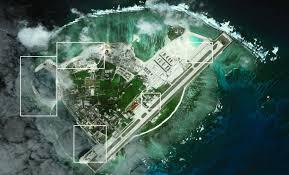
Multiple independent assessments confirm that China’s artificial island construction has continued well past the officially stated end date. Detailed satellite analysis by the Asia Maritime Transparency Initiative (AMTI) has documented ongoing development across both the Spratly Islands and the Paracel Islands, where China occupies a growing number of fortified outposts.

In the Paracel Islands, activity at Tree Island has resulted in a newly dredged harbour and approximately 25 acres of reclaimed land. Installations now include a helipad, two photovoltaic solar arrays, wind turbines, and other facilities consistent with military use. A cement plant suggests further construction is planned.
________________________________________________________________________

North Island, located nearby, has seen additional land reclamation since 2016. A large retaining wall encloses roughly seven acres of new land, protecting it from erosion. Structures under construction include a possible administrative building, and the layout suggests continued plans to connect the island with neighbouring Middle Island, a land bridge project previously washed out by typhoon damage.

On Woody Island—China’s main administrative and military base in the Paracels—permanent infrastructure has grown substantially. The island now features a 2,700-metre runway, hangars for combat aircraft, and HQ-9 surface-to-air missile batteries. A March 2017 satellite image confirmed the presence of a Shenyang J-11 fighter jet on the runway. Two large harbours have also been upgraded to support both military and civilian vessels.

Chinese officials have repeatedly denied current involvement in island reclamation. In 2017, Foreign Minister Wang Yi said publicly that “perhaps it is the country that brings up the issue that is doing it.” Satellite data from that same year and beyond shows Chinese construction clearly in progress, including dredging, new land creation and the addition of permanent infrastructure.
Strategic Positioning Through Layered Infrastructure
The Spratly Islands, further south, now host China’s most heavily developed artificial positions. Features such as Fiery Cross Reef, Mischief Reef, and Subi Reef have been transformed into major military outposts, each equipped with 3,000-metre runways, hardened aircraft shelters, radar installations, barracks, and fuel storage facilities.

These locations form a network of overlapping capabilities. Fiery Cross Reef supports port facilities, radar systems, and anti-aircraft defences. Subi Reef includes a military-grade runway and extensive storage structures. Mischief Reef is notable for its deepwater port, large-scale barracks, and communications systems. The layout and infrastructure at all three mirror those seen on Woody Island, suggesting coordinated design for power projection and surveillance.
According to the U.S.-China Economic and Security Review Commission, over 12 square kilometres of land were created by China between 2013 and 2015, far exceeding the combined total reclaimed by other claimants in the region over the previous 40 years.

In the Paracels, Palm and Duncan Islands have been linked via a land bridge, forming China’s second-largest base in the chain. The site includes a helicopter base, eight helipads, and hardened hangars, which analysts suggest could support anti-submarine warfare operations. A large central harbour accommodates both military and supply ships.
Triton Island, closer to the Vietnamese coast, has seen recent upgrades including a new helipad and visual markings declaring Chinese sovereignty. Pattle Island, Money Island, and Lincoln Island all feature harbours and support buildings, with new infrastructure appearing in satellite imagery taken in late 2016 and early 2017.
________________________________________________________________________
Reactions From Neighbours and Strained Diplomacy
Neighbouring governments have grown increasingly vocal. Vietnam has undertaken limited land reclamation of its own, but at a fraction of China’s scale. The South China Sea dispute continues to feature prominently in ASEAN meetings, where member states are divided over how strongly to respond.
During the 50th ASEAN Foreign Ministers’ Meeting in Manila in 2017, internal disagreements almost derailed the final joint statement. After lengthy negotiations, the group acknowledged concerns over land reclamation and called for restraint. The language remained cautious, reflecting political pressure from various member states with differing strategic ties.

Despite this, the construction continues. AMTI has identified Chinese military installations on at least 20 outposts in the Paracels, many with hardened structures, helipads or protected harbours. While the Spratlys have received more international attention, changes in the Paracels reflect a long-term strategy of entrenchment across the broader maritime theatre.
Environmental Degradation Beneath the Strategy
Satellite imagery and independent assessments indicate that significant ecological damage has accompanied the expansion. Dredging and sediment plumes have destroyed coral reefs and altered current patterns. Between 12 and 18 square kilometres of reef habitat are estimated to have been lost.
Some of the damage has been acknowledged in Chinese research. Domestic scientific reports note that marine life has been ‘eradicated’ within the zones directly affected by construction. Ecosystem disruption has extended well beyond the immediate footprint of island-building sites.
Chinese agencies have downplayed these effects, attributing reef decline to broader challenges such as climate change and ocean acidification. The Chinese Oceanographic Administration maintains that all island construction followed environmental protocols and did not significantly impact coral health.
Independent experts disagree. Regional marine biologists have highlighted changes in sedimentation and water chemistry that correlate with construction activity. The long-term effects on regional biodiversity and fish stocks remain under active study.
NOTE – This article was originally published in Indian Defence Review and can be viewed here


