Eastern Pacific could soon face its first hurricane of the season. Tropical Storm Christina should become a hurricane Cristina within the next 2 days as very favorable conditions are present in the region. The system will remain away from any land areas but should become an impressive hurricane on satellites by Thursday.
Cristina is packing maximum sustained winds of 35 knots (40 mph), gusting to 45 knots with a central pressure of around 1008 mbar and deepening. The system has been upgraded from the tropical depression 97E overnight.
There is another tropical system ongoing – a tropical disturbance #98L along the Carolina’s coast. It could develop dangerous flooding threat along the East Coast in the coming days:
Satellite imagery
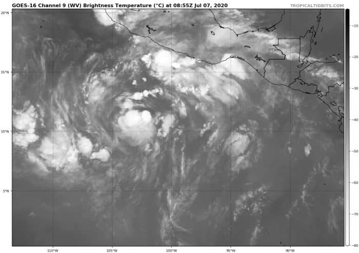
Attached are the water vapor and visible satellite images across Eastern Pacific. A broad area of circulation is seen with the Tropical Storm Cristina, gradually emerging together. The environment is conducive for further development of the system. A compact inner core has also been observed in satellite data, suggesting the system is healthy enough for strengthening.

WV satellite of Cristina.

VIS satellite of Cristina.
Prime conditions for hurricane development
A very moist environment with high precipitable water (PWAT) is present in the region. There is also favorable upper-level divergence and low deep-layer shear. Sea surface temperatures near 29 °C are very high as well. Therefore, conditions are prime for the first hurricane development this season.

PWAT chart across Eastern Pacific. Graphics: CIMMS
The favorable environment is also confirmed by the Ocean Heat content (OHC) chart across the Eastern Pacific, especially over the next 24-48 hours. These conditions should normally boost the intensity of a tropical system. Therefore, we can expect to see a rather rapid development of hurricane Christina through Wednesday.

Forecast track
The high-resolution forecast animation below, made from the GFS model, shows the strengthening of Cristina, as it moves further northwest. Notice the second tropical system developing behind Cristina, also trying to develop into a hurricane.
Read Also : Sri Lanka Rangers Spot Possible Rare Baby Elephant Twins,https://greenstories.co.in/baby-elephant-twins/
Tropical storm Cristina becomes a hurricane
Tropical storm Cristina becomes a hurricane – July 2020Play Video
The National Hurricane Center (NHC) is forecasting Cristina could become a Category 1 hurricane by Wednesday. Potentially even a Category 2 system on Thursday. Packing around 90 knots (= 105 mph) maximum sustained winds. Its movement will be west-northwestward at about 10-15 kt. The track forecast is fairly straightforward.

NHC track for Cristina.

GEFS model forecast track for Cristina. *
Intensity forecast for Cristina

Intensity forecast for Cristina. ++
As we can see on the infrared satellite simulation chart for Friday morning, July 10th, hurricane Cristina could become a very organized and strong tropical system. Located over the open waters of Eastern Pacific, moving west. Away from any land areas of central America.


We are monitoring further development of Cristina and will be publishing more updates as hurricane strength emerges. Stay tuned!
Tags: #campmars, #echelon, #echelonfamily, #florida, #getgreengetgrowing, #gngagritech, #greenstories, #hurricane, #jaredleto, #jaredletoismyhusband, #marsamerica, #marsarmy, #monolithtour, #provehitoinaltum, #secondstomars, #shannonleto, #stm, #thekill, #thirtysecondstomars, #thisiswar, #yesthisisacult


